Annual Fall Field Conference

Regional geology and evaporite karst phenomena of the lower Pecos region, southeastern New Mexico and west Texas
(October 4-7, 2023; limited-capacity pre-meeting field trips on October 3 and 4)

Mirror Lake

Mirror Lake, a compound sinkhole lake at Bottomless Lake State Park east of Roswell, NM, formed in evaporitic rocks of the Seven Rivers Formation.

The 73rd annual Fall Field Conference of the New Mexico Geological Society will be held in the Carlsbad area of southeastern New Mexico, a region last visited by the Society in 2006. The 2023 conference will focus specifically on evaporite karst of the lower Pecos region, and more broadly on the geology and stratigraphy of the Delaware Basin in west Texas and southeastern New Mexico. This region is of immense economic and scientific importance due to its prolific oil and gas production and its designation by the International Union of Geological Sciences as a Global Stratotype Section for rocks of middle Permian age. Evaporite karst phenomena formed in middle and upper Permian strata occur on a variety of scales and are broadly distributed throughout the region.

The 2023 Fall Field Conference will be sponsored by the National Cave and Karst Research Institute. The hosts for this year’s conference are Lewis Land (National Cave and Karst Research Institute), Kate Zeigler (Zeigler Geologic Consulting), Peter Hutchinson (THG Geophysics), Issam Bou Jaoude (National Cave and Karst Research Institute), and David McCraw (NMBGMR, ret.).

Itinerary

(PDF version available)

Pre-conference field trips

The conference itinerary includes three pre-conference field trips. Note that there is a possibility of a Federal Government shutdown starting September 30th, which may affect the pre-meeting field trips in National Parks. Should that happen, registration fees for those trips will be refunded.

Nogal Canyon

El Capitan, the southernmost exposure of the Capitan Reef at the southern prong of the Guadalupe Mountains.

Field trip one:
A hike to the crest of Guadalupe Peak, at 2,667 m (8751 ft) the highest point in the state of Texas. This hike will provide participants with exposures of the entire sequence of facies changes in middle Permian (Guadalupian) rocks, from deepwater sands and limestones of the Delaware Mountain Group, past exposures of the Capitan Reef, and backreef units of the Tansill Formation. The crest of Guadalupe Peak provides spectacular views of the Delaware Basin and El Capitan at the southern prong of the Guadalupe Mountains. This is a strenuous hike that involves an elevation gain of approximately 1000 m. Participants are advised to wear sensible shoes and pack plenty of water. The complete round trip will take approximately eight hours and for this reason will take place on Tuesday, October 3, the day before the Wednesday evening icebreaker. To ensure an early start Tuesday morning, we suggest that hikers camp out Monday night at the Pine Springs campground near the Guadalupe Mountains National Park Headquarters.

Nogal Canyon

Cornudas Mountain is a syenite laccolith.

Field trip two: CANCELLED
We are planning a pre-meeting field trip to the Cornudas Mountains, to highlight new mapping, petrography, 40Ar/39Ar geochronology, and geochemical analyses that have provided a better understanding of the emplacement of these intrusions and associated mineral deposits. Re-examination of the rare earth elements (REE) deposits in the Cornudas Mountains is warranted in light of today’s economic importance of critical minerals, including REE that are essential in most of our electronic devices. The Cornudas Mountains form the northern Trans-Pecos alkaline Magmatic Province in the southern part of the North American Cordilleran alkaline-igneous belt. The igneous rocks in the Cornudas Mountains were emplaced in two pulses at 37.14–34.5 Ma and 32.48–26.95 Ma, just prior to or during the early phases of Rio Grande Rift extension, and consist of (1) larger nepheline syenite to syenite laccoliths (Wind Mountain, Deer Mountain, San Antonio Mountain, Cornudas Mountain), (2) phonolite and nepheline syenite sills (Alamo Mountain, Flat Top Mountains, Chattfield Mountain, Washburn Mountain, and Black Mountain), (3) smaller syenite to nepheline syenite intrusions in Chess Draw, and (4) numerous syenite, nepheline syenite, volcanic breccia, and phonolite dikes that intrude Permian and Cretaceous sedimentary rocks. We will start near the Border Patrol Station at the intersection of US 54 and NM 506 at 8 AM on Tuesday, Oct. 3, caravan to the Cornudas Mountains, examine the intrusions and REE deposits. Participants can then travel on to Carlsbad afterwards and arrive late in Carlsbad Tuesday evening. Monday evening participants can stay on their own in Alamogordo.

Nogal Canyon

Giants in Carlsbad Caverns

Field trip three:
A geologic tour of Carlsbad Cavern, probably the most famous cave in the western United States for its enormous rooms and spectacular decorations, and one of three World Heritage Sites in New Mexico (the other two are Taos Pueblo and Chaco Canyon). The trip begins at the natural entrance and will include a hike down to the Big Room, one of the largest cave chambers in North America by volume. Carlsbad Cavern is formed in the middle Permian Capitan Reef and associated backreef units. Over the course of the trip attendees can observe world-class speleothems and primary sedimentary structures within the reef complex. The hike to the Big Room involves a 230 m (755 foot) descent on paved trails with artificial lighting, and an elevator for transport back to the surface. This trip will take place on Wednesday, October 4, and is limited to 36 participants.

Icebreaker

Wednesday, 10/4/2023 — 6:00pm-9:00pm at Washington Ranch.

Light food with a complementary drink will be provided. A cash bar will also be available.

Main Conference

Day 1 (Thursday, 10/5/2023):
Regional geology of the Guadalupe Mountains and Delaware Basin, and evaporite karst of the Castile Formation.

The day will begin with exposures of the upper Permian (Ochoan) Castile gypsum at the famous State Line roadcut on National Parks Highway. At this roadcut the section consists of couplets of white to gray gypsum laminae 1-5 mm in thickness, alternating with dark-brown laminae containing a mixture of calcite and organic matter. The gypsum-calcite couplets have been interpreted as seasonal varves, in part because of their remarkable lateral continuity; individual laminae have been traced across the Delaware Basin for over 110 km. The next two stops will feature exposures of deep-water sands and limestones of the Delaware Mountain Group, including evidence of a submarine debris flow at the base of the Rader Member of the Bell Canyon Formation. Limestone clasts ranging from pea-size pebbles to boulders the size of a car are embedded in deep water Bell Canyon sandstones. The route passes directly below El Capitan, a striking and much photographed promontory at the southern end of the Guadalupe Mountains, formed in rocks of the Capitan Reef and associated forereef talus. The remainder of the day will be spent at Chosa Draw, an eerily beautiful landscape and a classic example of the Gypsum Plain/Chihuahua Desert ecosystem, where we will explore caves and sinkholes formed in the Castile gypsum, including Parks Ranch Cave, the second longest gypsum cave in the United States.

The BBQ dinner will be served in the evening at Washington Ranch.

Day 2 (Friday, 10/6/2023):
Karst hydrology of the Black and Pecos Rivers, and gypsum karst of the Seven Rivers Hills.

The second day will begin with a walking tour of the Quaternary geology of Washington Ranch, including outcrops of the Quaternary gravel conglomerate of the Black River Basin. These rocks are formed from gravels eroded from the Guadalupe Escarpment a few km to the north, locally cemented by calcium carbonate to form a hard limestone cobble conglomerate. The most visually striking surface features at Washington Ranch are the extensive tufa deposits that line the Black River and form tufa dams at five different locations. Casts of reeds and other aquatic plants are some of the more common features seen in the tufa deposits. The Quaternary gravel unit has been described as a locally important karstic aquifer, based on the presence of springs, sinkholes, and solutionally enlarged cavities in the carbonate-cemented gravels. Subsequent stops in the area include Rattlesnake Spring, fed by discharge from the Quaternary gravel aquifer, and the source of water supply for Washington Ranch and the visitors center at Carlsbad Caverns NP. That afternoon we will travel north and visit Carlsbad Spring on the Pecos River, which discharges from a karstic aquifer formed in the Capitan Reef, the principal source of drinking water for the city of Carlsbad. The afternoon will conclude with a visit to the Seven Rivers Hills, where sinkholes and caves formed in gypsum and mudstone of the Seven Rivers Formation provide evidence of past upward flow of groundwater from an underlying artesian aquifer.

The banquet dinner will be served in the evening at Washington Ranch.

Day 3 (Saturday, 10/7/2023)
Middle Permian backreef facies changes and giant gypsum cenotes:

The day begins with a drive up the Queen Highway along Rocky Arroyo, north of Carlsbad. This portion of the route begins a traverse through the famous transition from near-backreef dolomites to far-backreef evaporites within the Seven Rivers Formation, a shelfward facies change that occurs over the course of just one mile. The traverse concludes at the Teepee structure, a conical hill of redbeds and gypsum capped by more resistant dolomites of the Azotea Tongue of the Seven Rivers Formation. The Teepee, with its classic symmetry, is one of the best-known examples of the erosional hills formed in gypsum and redbeds and capped by dolomite that are ubiquitous landforms in the Seven Rivers Embayment. The conference concludes at Bottomless Lakes State Park east of Roswell, where giant gypsum cenotes are formed in the Seven Rivers Escarpment. These sinkhole lakes are fed by upward artesian flow from an underlying karstic aquifer, and occur at the downgradient end of the regional hydrologic system in the Roswell Artesian Basin. Spring sapping at the base of the escarpment has resulted in oversteepening of the eastern walls of the cenotes, causing occasional rockslides and other mass-wasting events, an indication of the fundamental role that gypsum karst processes have played in shaping the morphology of the lower Pecos Valley.

Lodging

Lodging for the conference will consist of bunkhouse and tent camping at Washington Ranch southwest of Carlsbad, a retreat located in a beautiful cottonwood grove along the banks of the Black River, one of the southernmost tributaries of the Pecos River in southeastern New Mexico. Unique exposures of Quaternary conglomerates and tufa dams can be found along the banks of the Black River, along with flocks of wild turkeys. All lodging and meals, including the banquet and barbecue, are included in the registration cost for the conference. Those attendees staying in the bunkhouses, be advised that bed linen is not included so please bring your own sleeping bags and pillows. Check out their website, https://campwashingtonranch.org/ (but note, tent camping is in fact allowed at Washington Ranch, in spite of the incorrect info on that subject on their website).

Health

We will follow any public health orders that are in effect during the conference. We encourage members attending the conference to be fully vaccinated against COVID-19.

Future Conferences:

Widespread enthusiasm for the Fall Field Conferences has led to receipt of many proposals for future conferences. Therefore, the schedule of upcoming field conferences is now outlined for the next several years. The field conference venues and names of organizers are listed below. All members are encouraged to volunteer assistance to the organizers or to contribute to the guidebooks. If you live near or are involved with the geology in the vicinity of the future conference sites, please consider contacting one of the organizers.
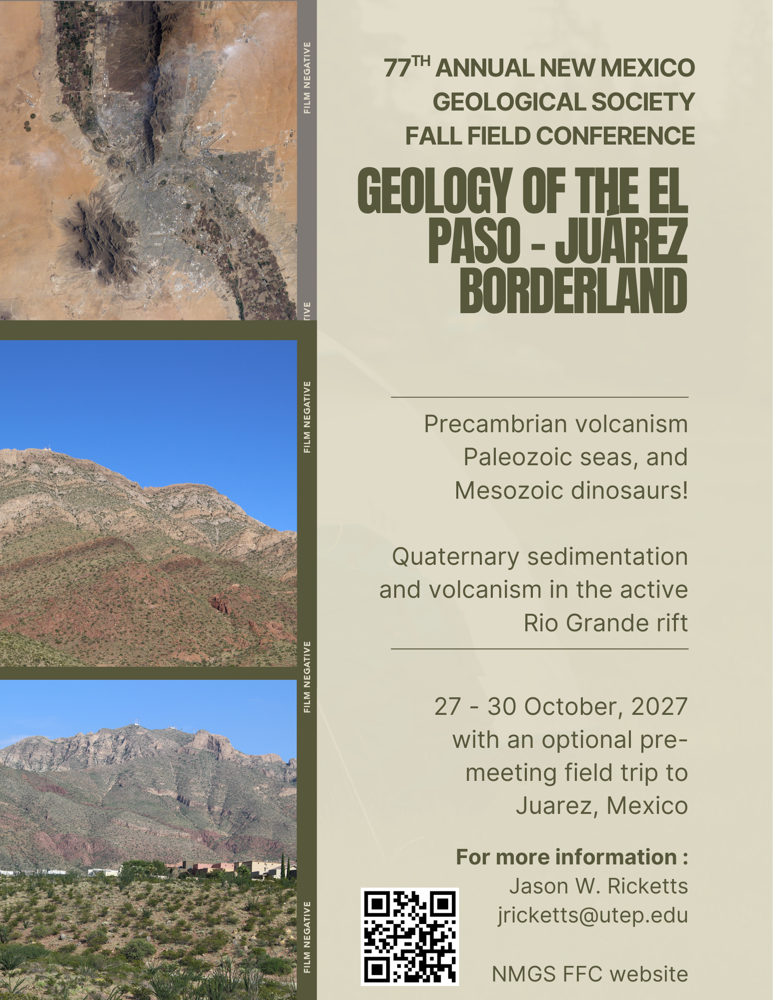
2024: Nacimiento Mountains
2025: Eastern San Juan Basin
2026: Albuquerque Area


If you have an idea for a future field conference, please contact the President of the NMGS.

Photos From Past Fall Field Conferences

Everyone is invited to share their best digital photos of past conferences with the rest of the Society membership. Please contact the society webmaster via the 'comments' link below.